Oil Field Plume Intactness: Kuwait Oil Field
Fires
The following pictures are from taken from the U.S. space shuttle on different
flight. The captions and commentary indicate which flight. The pictures show
the wind pattern over Kuwait that primarily goes south into Saudi Arabia
on an increasingly westerly direction as it approaches the equator. This
wind direction takes not only the oil plumes from burning oil wells but the
CO2 plumes from gas flaring from the same wellheads. Key phrases have been
highlighted. The integrity of wind bodies is also shown
in volcanic plumes and
Sahara-to-Texas
Duststorms.
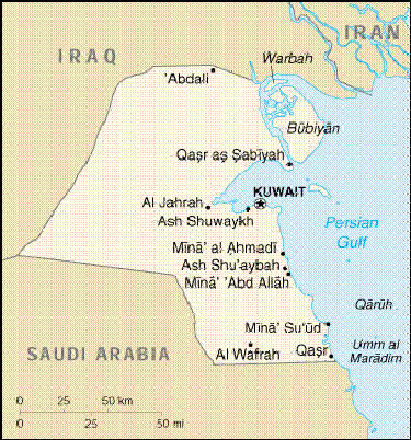
| Kuwait Map: The below map can be used to reference the images
based on Kuwaiti Bay as a landmark (the body of water above the star indicating
KUWAIT city) |
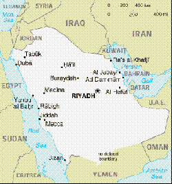
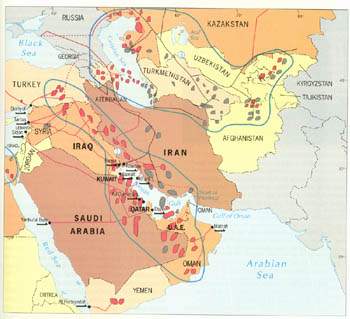
MidEast Map: Kuwait's relative position above Saudi
Arabia at the top of the Persian Gulf. Africa is to the lower left,
e.g., Eritrea |
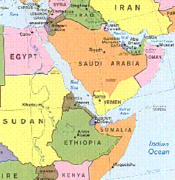
Horn of Africa Drought Countries: Geographically, the East African
Drought is downwind from oil fields of the MidEast: Saudi Arabia, Kuwait,
Oman, etc. |
 |
 |
 |
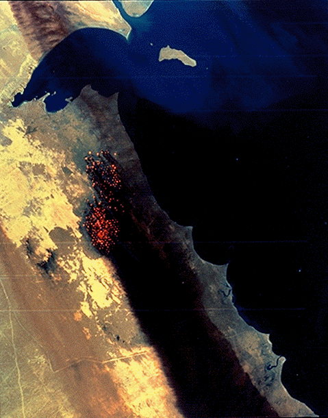
| STS037-73-047
"Smoke from the burning oil fields to the north and south of Kuwait City,
seen on the south shore of Kuwayt Bay almost totally obscures the view of
the tiny, but oil rich, nation of Kuwait (29.0N, 48.0E). During the brief
war between Iraq and the Allied forces, many of the oil wells in Kuwait were
destroyed and set afire. For several months, those fires burned out of
control, spewing wind borne smoke and ash for hundreds of miles." [The
map at the right shows that how the oil field plumes go to the southwest,
e.g., notice Bubiyan Island and the Kuwayt Bay] |
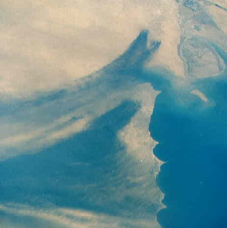
|
Amazing that such a small area can source so much wealth and despair. |
|
| STS043-151-220: "This view up the Persian Gulf from the Qatar
Peninsula into southern Iraq (25.5N, 51.0E) shows an excursion of the smoke
plumes from the Kuwait oil fires set during the short Persian Gulf War. Smoke
from the fires north of Kuwait City, extends across the Persian Gulf while
a larger smoke plume from the southern fires heads into southern Saudi
Arabia before beginning to spread out and become more diffuse."
This is probably the best visual, photographic proof of how the CO2 plumes
of oil fields remain intact for great distances. The tail of the southern,
larger plume extends halfway across Saudi Arabia beyond its capital of Riyadh.
Riyadh is under the clouds to the left of the plume.
(Volcano plumes maintain the same
intactness.)
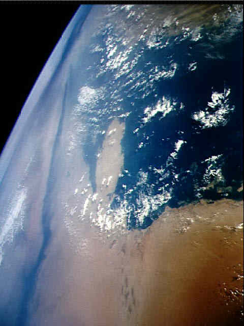 |
The larger plume is the black streak on the left starting
about 1/4 in from the left and about 1/4 down from the top. It extends to
the lower left corner. Riyadh, the capital of Saudi Arabia, is under the
clouds on the edge about 2/3 down.
The photo at the left was taken from a position above the "E" in
abbreviation of "U.A.L." for United Arab Emirates. looking westward. Note
the little dimple peninsula in the map (upper left of "U") and in photo.
The lower corner of the photo is more than halfway across Saudi Arabia.
Please recognize that not only do you not see the CO2 plumes that
the
Saudi
oil fields are
adding--Saudi
flaring, but normally, you don't see the Kuwaiti either. Nonetheless,
like heroin streaming in the blood stream invisible to the naked eye,
the harm is still there. |
|
| Firehose Analogy: The above
smoke tail is like an unmanned firehose, swishing back and forth as it discharges
its stream of water only the shifting deviations from the prevailing wind
patterns makes the tail sweep back and forth. Based on the bell shaped curve,
the spot at the peak of the curve gets the most water with the areas to each
side getting less and less from the primary focus of the hose. The only
difference is that the hoses are not hooked up to water hydrants but to
dessicating hydrators. Instead of water being spread in an arch, water is
absorbed as the CO2 plumes sweep, snake and twist across the downwind
landscape. |
| The photo at the left shows a closer view of the two Kuwaiti
plumes with the actual fires burning.
The oil plumes remain intact for great distances: "Along much of the
coast, the smoke plume remained confined to a strip about 25 kilometers wide
in areas near the fires. As the plume moved off the Arabian Peninsula toward
the Gulf of Oman and India, it widened to about 60 kilometers and became
thinner. The smoke plume not only was relatively narrow, but limited in height,
typically having a base at about 0.5 kilometers and a top between 3 and 4
kilometers." Smoke
The tail of the plume shifts with the season as well as on individual
storm systems but the prevailing winds are southwest across
the Saudi peninsula. What the above comment about the oil well plumes going
both east and west is that seasonal variations can be found in the monsoons
of the Indian subcontinent.
The atmospheric integrity of bodies of air is also shown in
volcanic plumes and
Saharan duststorms
for thousands of miles. |
 |
| After the fires were put out, the scarred landscape had
a black track pointing south |
 |
|
|
|